|
The chart below shows the sky coverage for CFIS relative to some of the key, complementary surveys. CFIS-u requires extensive sky coverage away from the Galactic plane,
whereas the primary science drivers for CFIS-r require SDSS spectroscopy. We therefore will survey as large an area of the SDSS region as possible
to yield 7 galaxies per square arcminute for lensing. This is a similar galaxy density compared to RCS2, KiDS and DES, but over a much larger area than the
first two, and a better delivered image quality than the latter.
The survey parameters for CFIS are also chosen to provide essential, complementary, sky coverage to Euclid, which requires deep photometry in at least four Sloan bands
over the 15,000 square degrees of extragalactic sky (excluding the ecliptic plane due to the zodiacal light). The LSST will be in a position to observe the northern sky
from the g to the z-band at suitable depths up to a declination of +30 degrees. In principle, LSST could also observe in u-band at this declination, but observations would
be sub-optimal (high airmass and poor image quality) and there is no expectation this will occur. Complete coverage of the northern hemisphere in the u-band is therefore
important not just for the key CFIS science drivers, but also from the legacy perspective of the data.
The optimal area for CFIS-r to best complement Euclid and address the CFIS science goals is the northern 5,000 square degrees of the extragalactic sky. Priority
will be given to the subset of this area overlapping the SDSS footprint (3,300 square degrees). Both survey components are of importance to Euclid: while the depth of CFIS-u
is optimised to Galactic science and stellar populations, it reduces dramatically the number of catastrophic failures in photometric redshift determination at low and
high-z on the brighter sources. Both components overlap the DESI footprint and will be of use for enhanced targeting.
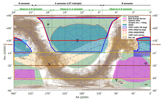
Legend: the CFIS-r (red outline) and CFIS-u (blue outline) with respect to other surveys on an equatorial projection of the entire sky. Points of interest are:
galactic poles (NGP/SGP), ecliptic poles (NEP/SEP), etc. The CFHT semester boundaries are indicated at the top (based on the LST at midnight) as well as the areas
that will be observed from the A and B semesters. This Mercator projection illustrates well the RA pressure of the survey but does not respect the relative areas
vs. declination, areas near the equator being larger. For example, the CFIS-u total sky area in blue is double of the CFIS-r outlined in red. Original image credit: T. Dwelly.
|